The 40 mile Apache Trail Scenic Drive that winds right through the Superstition Mountains sounded like a great way to spend the day. Ernie, our 2013 SUV Chevy Equinox was certainly up for the challenge. With his low, sporty front spoiler I was a bit worried but the unpaved section of the road was not a problem for Ernie. This being said, the narrow and rugged route requires attention while driving but offers endlessly unique views.

From Gold Canyon, which is just east of Phoenix, the drive starts in Apache Junction. The Superstition Mountains offer a rugged backdrop as you start heading out. Yes, they are ruggedly beautiful but that ruggedness is also what made them so hard for early travelers to navigate throughout history. I am happy to report that we didn’t really get lost on the drive, except maybe in the beauty of the backcountry.

During the 19th century, the main route through the mountains was a path carved by the Apaches– later adopted by stagecoach travelers—hence the name, the Apache Trail. It’s still one of the best ways to drive through the Superstitions and a whole lot safer I imagine now in a car than it was then. This trail is a modern driver’s dream and a big rig RV driver’s nightmare with hairpin turns, sweeping curves but loaded with stunning new views around every corner. Seriously, I can’t imagine bringing the Road House back on this wilderness road. The trail was turned into a road in the 1930s to support the development of dams along the Salt River with Theodore Roosevelt Dam being the big boy.
We thought about bringing Bentley except he isn’t a big fan of windy, hairpin turns but he sure would have loved to swim in Apache Lake.

Well graded!
There is a lot to explore along the way, mining history, ghost towns, three lakes and the amazing Roosevelt Dam. All this plus the natural beauty of the Superstition Mountains and the Tonto National Forest make for a great day of driving.
The Goldfield Mine and Superstition Mountain Museum are the first stop just outside Apache Junction. The museum offers exhibits that educate folks about the rich history of Arizona, starting with the story of the Apaches. The area is known for lore about lost mines and ghost towns. The museum may spark your interest about these mysteries but I am always a bit suspect of a museum that offers an Elvis Memorial Chapel along with a 20-stamp ore crusher. But who am I to judge, maybe some folks want to get married and host a reception at a museum with Arizona history and an Elvis Chapel!!
Speaking of suspect, the Goldfield Ghost Town is supposedly home to an authentic gold mine and the town that once boomed before it died out when the mine dried up. Guessing the original mining town didn’t have a zip line but they do now along with live gunfight reenactments, a Saloon now a restaurant, horseback rides and a narrow gauge railroad you can ride. Best I can tell there isn’t much left of the town itself that prospered there from 1892-1898. The current owners have done a good job of rebuilding the town so you do get the flavor of being in a old west town…okay, a really commercialized old west town!
One thing this area is rich with is history and natural beauty. The Lost Dutchman State Park is a great destination by itself for hiking, camping or picnicking. In the 1840s, the Peralta family of Mexico discovered gold near Apache Junction and continuously made trips to bring it back to Mexico. As the story goes, the family was ambushed by Apaches while on a gold expedition, leaving all but one or two family members left for dead. Decades later, Jacob Waltz, aka “the Dutchman,” was said to have found the mine, and hid gold in the Superstitions. When he died, he took the location of the mine to his grave.

The park is obviously named after the local lore around the Lost Dutchman and should you be curious about the tales of the Lost Dutchman Gold Mine or just want to take in some of the most gorgeous sections of the Superstitious Mountains, Lost Dutchman State Park will deliver. You can RV or tent camp in the park which is right at the base of those beautiful red cliffs. Better yet, spend an afternoon hiking and biking through the rugged trails that lead to Tonto State Forest. The park really is worth a day trip by itself even if you don’t camp.
But getting back to the scenic drive…the next place you will get to ogle is Canyon Lake. The great thing about this drive is that is gives you a good overview of some places you might want to come back and spend more time. Canyon Lake is one of four lakes created by Salt River dams (the others are Roosevelt Lake, Apache Lake and Saguaro Lake) and is strikingly beautiful.

I lost count of the one lane bridges on this drive. This is one of the newer bridges at Canyon Lake.
The lake offers scenic red canyons with calm water that beckons you to boat, ski, fish, or just take it all in. There is also a campground and the Lakeside Restaurant & Cantina. We have done some hiking in this area and always hope to see some of the local bighorn sheep perched atop the canyon!

No big-horn sheep again on this drive ~ WAH ~ but we did see these rough looking cows.
The next stop and the end of the paved road is at Tortilla Flat which was originally a stage coach stop and later a simple freight camp which supported the building of the dams. Tortilla Flat is Arizona’s smallest community – population 6 and still has a post office as well as a voters precinct. Like Goldfields, there is a bit of touristy vibe with a saloon, a mercantile and their own website but hey those 6 hardy peeps have to make a living too!

Tiny Tortilla Flat is nestled down in that dip at the base of the rocks in the middle of the picture.
Once the pavement ends so do all the tourist traps and now all you see is natural beauty for the next 40 miles. Granted the road is washboard with hairpins turns but this is some beautiful backcountry.

Apache Lake

Yes, there is a road somewhere in this picture!

It’s a devil Saguaro.
Back on the pavement again, we stopped to gawk at the massive Theodore Roosevelt Dam. It was originally constructed between 1905 and 1911 to control the erratic flow of the Salt River and to harness the water for irrigation. The dam turned the Arizona desert into land that could be farmed and was one of four dams constructed along the Salt River.
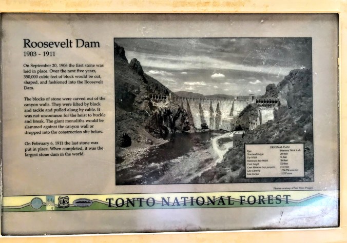
Theodore Roosevelt Dam is unique in the way it was originally constructed as it was the world’s largest “cyclopean-masonry” dam, a Greco-Roman style of building that uses huge, irregular blocks. These massive blocks were cut out of the surrounding hills…can’t imagine how they were hoisted up over three hundred feet. The dam was later modified in 1996 and is covered by new concrete and stands 357 feet tall. The modifications expanded the lake’s storage capacity by 20 percent — enough for 1 million more people. Phoenix metro is over 4.5 million people and growing so the water and hydropower are vitally important resources.

It’s quite an impressive site…those spillways are massive.

Lake Roosevelt is on the other side of that ginormous dam.
By now we had worked up an appetite so we made a lunch stop in Globe at Nerdburger…great homemade burgers in a funky diner. The town of Globe relies on the mining industry which is still alive and well in this area of Arizona.

Green Chile Cheeseburger anyone???

Over 65% percent of the copper output for the United States is mined in Arizona.
The total loop drive from Gold Canyon RV Resort was about 127 miles and my only disappointment was the overcast skies which don’t make for the best photography. Hmmm, maybe I just have to go back on a sunny day!!!

Okay, now I bet you want to plan a visit to Arizona so here are a few books that you might enjoy!


Our38ftlife is a participant in the Amazon Services LLC Associates Program, a program designed to provide a means for sites to earn advertising fees by advertising and linking to amazon.com. We very much appreciate any purchase you make via our website links. There is no additional cost to you and helps support this blog.


That is such a fun way to spend a day. Over the year’s, we’ve driven the entire loop twice. Other times, we’ve taken guests as far as the scenic overlook just past Tortilla Flat then turned around. I never tire of the scenery. Great write up and photos showcasing the unique beauty of the area. Camping at Lost Dutchman SP is one of our favorites!
LikeLiked by 1 person
Your pictures came out very nice even with clouds. No need for a redo.
LikeLiked by 1 person