What do you do when it’s 96 degrees outside???
- Stay inside with the AC on – Boring!
- Head to the mall for a retail intervention – No Way!!!
- Hang at the pool and lounge in your floatie – Hmm, not a bad idea.
- Take a road trip somewhere cooler – BINGO!!!
The forecast in the Phoenix Metro area was hot, hot, hot a couple of weeks ago with two days being in the high 90’s so the idea of spending a day somewhere cooler was appealing. We would normally have been on the road by now and out of hot Arizona but a trip back to KY to see my Mother and attend a family reunion is on the agenda for late April. I found a ridiculously inexpensive flight, nonstop from Mesa Gateway airport to Louisville on Allegiant Air some months ago so we were locked into staying in the area until my return. So buck up and get through some hot days was my mantra but geez, there were a lot of them on the horizon.
After looking at a heat map, Flagstaff at 6,910 foot elevation was offering up a 74 degree day and three national monuments that we had not seen. SOLD…we even got up early – 6am early – which we rarely do anymore, to pick up our friends in Mesa and get on the road. It’s about 175 miles to Flagstaff from Mesa but all easy freeway driving.
Not only does Flagstaff offer some great outdoor excursions, it has a charming, vibrant old downtown area with loads of great restaurant choices. If craft beer is your thing, you will be right at home in “Flag” – as the locals call it! We had some good grub and brew at the The Lumberyard Brewing Company.

The historical downtown area has some really cool old neon signs.
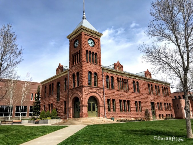
The county courthouse has been beautifully restored.
Flagstaff’s early economy was based on the lumber, railroad, and ranching industries. Today, the city remains an important distribution hub for companies such as Nestlé Purina PetCare, and is home to Lowell Observatory, the U.S. Naval Observatory, the United States Geological Survey Flagstaff Station and Northern Arizona University. Flagstaff has a strong tourism sector, due to its proximity to Grand Canyon National Park, Oak Creek Canyon, the Arizona Snowbowl, Meteor Crater, and historic Route 66. So much to do here….

Love this old sign…the inside of the hotel is just as nicely restored.

The Weatherford Hotel has survived since 1887 and has a great story.

Right off the historical Route 66, old town would be a great place to stay if your’e planning a visit.
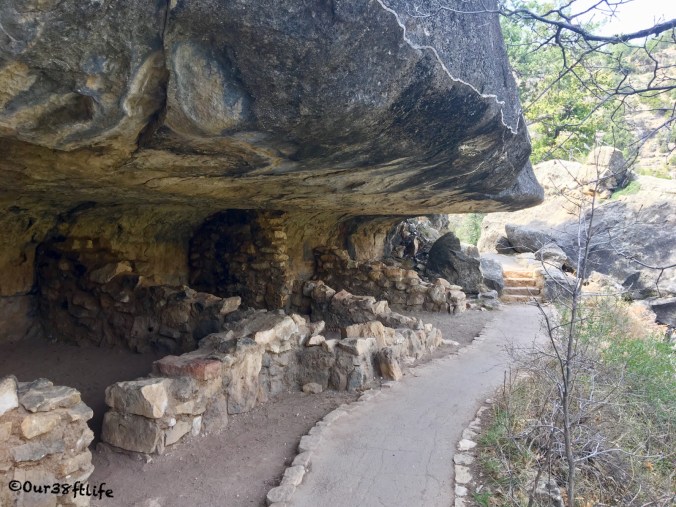
Yes, seriously there is a ski area in Flagstaff which we were tempted to check out but the idea of being that cold wasn’t that appealing. Instead, we drove straight out to Walnut Canyon National Monument and did the 1 mile Island Trail hike.
More than 700 years ago Walnut Canyon was a vital pueblo community and this 4 1/2 mile long canyon has over 200 caves. We hiked the Island Trail that leads you back in time and highlights 25 cliff dwelling rooms along this part of the canyon with more being visible across the canyon.

Can you see all the dwellings along the ledges?
While not a long hike, this trail takes you down 240 steps and back in time when you can imagine a thriving pueblo community who’s cave dwellings ring the canyon walls. Going down was a piece of cake but coming back up was a bit of an aerobic workout considering we were at almost 7,000 ft elevation.

Sinagua is Spanish for “without water”. By living in such a dry region the Sinagua were believed to have become experts at conserving water and dealing with droughts. Walnut Canyon was supplied a vital water resource and was 350 feet below the canyon rim. Now that’s a hike and no nice steps either !!! The Sinagua were also believed to have been active traders that stretched to the Gulf of Mexico and even as far as Central America.

These resourceful people built their homes under limestone ledges, deep within the canyon, taking advantage of the natural recesses in the limestone cliff walls which were eroded over millions of years by flowing water.
It is thought that the Sinagua left around 1250 CE because of fear of neighboring tribes or droughts, of course no one knows for certain but they left over 80 cliff dwellings behind.

After lunch in town, we headed back out to explore the Sunset Crater National Monument and the Wupatki National Monument which are not far apart. Truly this area deserves more than the 8 hours we spent touring so if you do plan a trip here just know you can see all three monuments in a day but why not stay a few days and enjoy the ambiance of “Flag”.

There are some great hikes at Sunset Crater and the geology is fascinating.
A major population influx began soon after the eruption of Sunset Crater in the 11th century (between 1040 and 1100). The eruptions covered the area with volcanic ash which is believed to have improved agricultural productivity and the soil’s ability to retain water. This area supported crops like maize and squash which were raised from the arid land without irrigation.
By 1182, approximately 85 to 100 people lived at Wupatki Pueblo but by 1225 this site was also abandoned. It would be fascinating to how what happened in this era that caused so many of our ancient people to simply disappear.

The ruins of a “Tall House”.
At one time, there were many settlement sites scattered throughout the monument which were built by the Cohonina, Kayenta Anasazi, and Sinagua. Wupatki was first inhabited around 500 AD. Wupatki, which means “Tall House” in the Hopi language, is a multistory Sinagua pueblo dwelling comprising over 100 rooms and a community room and ball court, making it the largest building for nearly 50 miles. Nearby secondary structures have also been uncovered, including two kiva-like structures.

So much history here in the SW … I often leave an area with way more questions that I will ever have answers but that’s what makes traveling so compelling.